ANUClimate is a spatial model developed by Michael Hutchinson that integrates a new approach to the interpolation of Australia’s national point climate data to produce climate variables on a 0.01° grid.
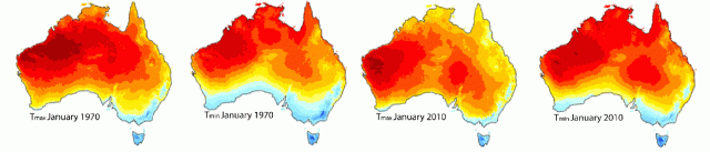
The available high-resolution climate data sets span the period from January 1970 to December 2013. ANUClimate incorporates several new features such as improved background-anomaly interpretation and a new “proximity to coast” modifier, which captures the marine perturbation of daily minimum and maximum temperature. This means that temperature and both positive and zero rainfall can be effectively interpolated by the thin plate splines method, which has adaptive capacities. Therefore, monthly mean are topographically corrected and yield influence of atmospheric processes and terrain.
The model includes two Digital Elevation Models with differing spatial complexity derived from GEODATA9 second DEM version 3 to support modelling of surface climate and related earth surface processes for the Australian continent.
Most climate values have been modelled by expressing each value as a normalised anomaly with respect to the gridded 1976-2005 mean. These means and anomalies were all interpolated by trivariate thin plate smoothing spline functions of longitude, latitude and vertically exaggerated elevation using ANUSPLIN Version 4.5, with additional dependences on proximity to the coast for the temperature and vapour pressure variables. Station elevations for the gridded temperature and vapour pressure variables were obtained from 0.01° local averages of grid values from the GEODATA 9 second DEM version 3. Station elevations for the gridded rainfall and pan evaporation variables were obtained from 0.05° local averages of grid values from the GEODATA 9 second DEM version 3.
Monthly temperature estimates are improved by around 25% and precipitation estimates by 7-15% compared to Jones et al. (2009) RMSE cross-validation. However, the model makes no further improvement on accuracy below the 1km resolution.
The main aim of this project is to support the modelling of the spatial distributions of plants and animals, to make long-term estimates of land surface processes for assessment of agriculture and biodiversity, and to provide a baseline for the assessment of the impacts of projected climate change.
Key product links:
http://fennerschool.anu.edu.au/research/products/anusplin-vrsn-44
http://fennerschool.anu.edu.au/research/products/anuclim-vrsn-61
![]()

![]()
